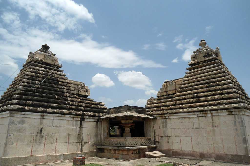
District Overview
Nalgonda district is located in the southern part of the Indian state of Telangana. The present district was formed on 11 October 2016 following the reorganisation of the erstwhile undivided Nalgonda district, which resulted in the creation of Nalgonda, Suryapet and Yadadri Bhuvanagiri districts.
The district headquarters is Nalgonda town. The district shares boundaries with Suryapet, Rangareddy, Yadadri Bhuvanagiri and Nagarkurnool districts, as well as the state of Andhra Pradesh.
Nalgonda has a rich historical and archaeological landscape associated with the Kandur Chodas, Kakatiyas, Recherla Nayakas, Padma Nayaka rulers and other Deccan dynasties. Its heritage includes the temple complexes at Panagal, the medieval Devarakonda Fort, Buddhist archaeological remains at Nandikonda and the historic region around Nagarjuna Sagar.
The district is also an important agricultural and industrial region. The Krishna River, Nagarjuna Sagar Project, Musi River and Dindi River form important parts of its geography and irrigation landscape.
Population: 16,18,416 (2011 Census district data) | Area: 7,112 km² | Headquarters: Nalgonda
Discover Nalgonda – Where Ancient Heritage Meets the Krishna Valley
Nalgonda is a district where medieval temple architecture, hill forts, Buddhist archaeological remains, river landscapes and modern industry come together. The historic village of Panagal is renowned for the Chaya Someswara and Pachala Someswara temples, which preserve remarkable stone architecture and sculpture.
The Devarakonda Fort, associated with the Recherla and Padma Nayaka rulers, stands among the surrounding rocky hills. Near the Krishna River, Nandikonda preserves archaeological associations with the Ikshvaku period and Buddhist monastic remains.
Other notable destinations include Nagarjuna Sagar Dam, Wadapally at the Krishna–Musi confluence, Yelleswaragattu and seasonal waterfalls in the district.
Top Attractions in Nalgonda
Temples & Heritage
Sri Chaya Someswara Temple
An 11th–12th-century temple at Panagal, famous for its distinctive architectural arrangement and the pillar-shadow phenomenon inside its sanctum.

Pachala Someswara Temple
A historic Shiva temple at Panagal, known for its sculptured pillars, green stone Shiva Lingam, Nandi and distinctive multi-shrine architectural plan.

Yelleswaragattu Island
An island landscape in the Nagarjuna Sagar backwaters associated with the ancient Eleshwaram Mallanna temple and seasonal pilgrimage traditions.
Forts & Medieval Heritage
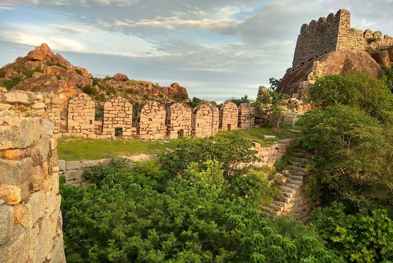
Devarakonda Fort
A medieval hill fort associated with the Recherla Nayakas and Padma Nayaka rulers, surrounded by rocky hills and containing historic temples and fortifications.
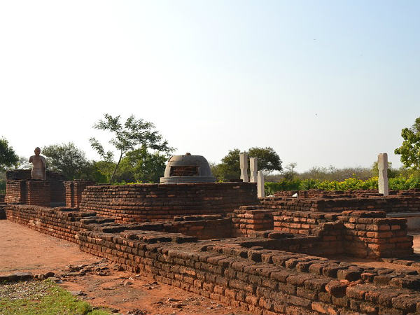
Nandikonda Buddhist Heritage
An archaeological locality near Nagarjuna Sagar associated with the Ikshvaku period, Buddhist monasteries, pillared halls, stupas and ancient fortifications.
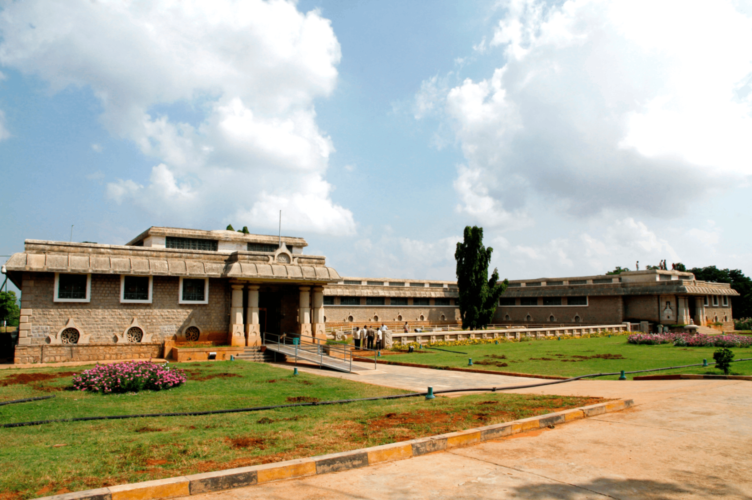
Nagarjunakonda Archaeological Heritage
The Nagarjunakonda region preserves important Buddhist and Ikshvaku archaeological remains. Its historic monuments were excavated and relocated during construction of the Nagarjuna Sagar reservoir.
Nalgonda's Buddhist and archaeological heritage is particularly associated with the Krishna Valley, the Ikshvaku period and the historic settlements around Nagarjuna Sagar.
Nature, Waterfalls & Reservoirs

Nagarjuna Sagar Dam
A major masonry dam across the Krishna River, built for irrigation and hydroelectric generation and recognised as an important engineering and tourism landmark.

Bugga Waterfall
A seasonal series of small cascades associated with Bugga village or Bugga Thanda. The approach involves rocky terrain and a strenuous forest trek; exact access should be confirmed locally.

Nuthankal Waterfall
A seasonal cascade described in Telangana360's Nalgonda collection. The precise village identification and district boundary should be checked before planning a visit.
Travel Guide
How to Reach
By Road: Nalgonda town is connected by road to Hyderabad, Miryalaguda, Devarakonda, Suryapet and other major towns in Telangana. Regular TSRTC bus services connect Nalgonda with Hyderabad and neighbouring districts.
By Rail: Nalgonda has a railway station on the railway network connecting Hyderabad and other destinations. Regular train services connect Nalgonda with Secunderabad and other cities.
By Air: The nearest major airport is Rajiv Gandhi International Airport, Hyderabad. The district administration lists the airport at approximately 80 km from Nalgonda.
Best Time to Visit
October to February is generally more comfortable for visiting temples, forts, archaeological sites and river destinations. Summers can be hot, particularly in exposed hill-fort areas. Monsoon conditions may affect rural roads, waterfalls and trekking routes.
Safety Tips
- Carry sufficient drinking water, particularly when visiting forts and rural destinations.
- Wear suitable footwear at Devarakonda Fort and other rocky hill locations.
- Check boat services and local access arrangements before visiting reservoir islands.
- Follow temple regulations and dress respectfully at places of worship.
- Do not enter restricted archaeological areas or climb unstable fort structures.
- Check seasonal waterfall conditions before attempting treks.
- Confirm local transport and accommodation availability before visiting remote locations.
Where to Stay
- Nalgonda Town: District headquarters with hotels, restaurants and general visitor facilities.
- Miryalaguda: An important commercial and agricultural town with accommodation options.
- Devarakonda: Suitable as a base for exploring the fort and nearby countryside; confirm available accommodation.
- Nagarjuna Sagar: Accommodation options may be available around the reservoir and tourism facilities; confirm current availability.
Suggested Itineraries
One-Day Heritage Itinerary
- Morning: Visit the Panagal archaeological complex, including Chaya Someswara Temple and Pachala Someswara Temple.
- Afternoon: Explore the Panagal Museum and its collection of sculptures and archaeological objects.
- Evening: Return to Nalgonda town and explore local temples and markets.
Two-Day Fort & River Itinerary
- Day 1: Explore Devarakonda Fort and its surrounding hills. Overnight in a suitable nearby town.
- Day 2: Travel toward Nagarjuna Sagar and Nandikonda to explore the Krishna Valley and Buddhist archaeological heritage, subject to current access arrangements.
Temple & River Itinerary
- Morning: Visit Wadapally Sri Meenakshi Agastheeswara Swamy Temple.
- Afternoon: Visit the nearby Sri Lakshmi Narasimha Swamy Temple.
- Evening: Explore the Krishna–Musi Sangamam, subject to local access and river conditions.
History & Heritage
Name Origin: The name Nalgonda is derived from the Telugu words Nalla, meaning black, and Konda, meaning hill. The district administration also records the historical name Neelagiri and the later form Nallagonda.
Early History: The wider Nalgonda region preserves evidence of prehistoric habitation, early historic settlements, Buddhist remains and ancient inscriptions. The Krishna Valley was an important area of settlement and political activity during the early historic period.
Ikshvaku Heritage: The region around Nandikonda and Nagarjunakonda is associated with the Ikshvaku dynasty, which ruled parts of the eastern Deccan during the third and fourth centuries CE. Archaeological investigations revealed Buddhist monasteries, stupas, pillared halls and other structures.
Kandur Chodas: Panagal, historically known as Panugallu or Panagallu, was an important political and religious centre under the Kandur Choda chiefs and their predecessors. Inscriptions from the region provide evidence of grants, temple patronage and administrative activity during the medieval period.
Kakatiya Period: The Nalgonda region was part of the wider political and cultural landscape of the Kakatiya kingdom. Temples and inscriptions across the region reflect the influence of medieval Deccan rulers and their subordinate chiefs.
Recherla Nayakas and Devarakonda: Following the decline of the Kakatiya Empire in the 14th century, the Recherla Nayakas emerged as powerful regional rulers. Devarakonda Fort became an important stronghold associated with the Padma Nayaka rulers.
Modern District: The present Nalgonda district was established on 11 October 2016 during the Telangana district reorganisation. The former undivided district was divided into Nalgonda, Suryapet and Yadadri Bhuvanagiri districts.
Culture & Festivals
Maha Shivaratri: The historic Shiva temples at Panagal, Wadapally and other parts of the district attract devotees during Maha Shivaratri.
Karthika Masam: The temples at Panagal and Wadapally are associated with devotional observances during the Karthika month. Special prayers and lighting of lamps are part of local traditions.
Bathukamma: Telangana's floral festival is celebrated across Nalgonda district, with women arranging seasonal flowers, singing traditional songs and participating in community celebrations.
Bonalu: The Telangana festival dedicated to mother-goddess traditions is observed in different parts of the district.
Local Temple Festivals: Annual jatara celebrations and religious gatherings take place at temples throughout Nalgonda. Dates and rituals vary according to individual temple traditions.
Literary and Social Heritage: Nalgonda is associated with notable personalities of the Telangana literary, educational and social movements, including Vattikota Alwar Swamy and Doddi Komarayya.
Mandals of Nalgonda District
Nalgonda district is administered through four revenue divisions: Nalgonda, Miryalaguda, Devarakonda and Chandur.
Administrative data note: The district administration's mandal-page heading states 31 mandals, but the division-wise list on that same page contains 33 names. The district homepage also displays 33 blocks. The following list reproduces the division-wise names published by the district portal; the official count should be reconciled with the latest government notification.
Nalgonda Revenue Division – 9 Listed Mandals
Miryalaguda Revenue Division – 10 Listed Mandals
Devarakonda Revenue Division – 9 Listed Mandals
Chandur Revenue Division – 5 Listed Mandals
Source: Government of Telangana, Nalgonda District – Mandals / Blocks. Some names in the official division-wise list are marked as newly created mandals. The administrative count discrepancy is retained here for transparency.
Administration
Headquarters: Nalgonda town.
District Formation: 11 October 2016.
Revenue Divisions: 4 – Nalgonda, Miryalaguda, Devarakonda and Chandur.
Mandal Count: 31 according to the mandal-page heading; the division-wise list contains 33 names.
Population: 16,18,416 according to the 2011 Census data for the reorganised district.
Sex Ratio: 978 females per 1,000 males (2011 district data).
Literacy: 63.75% (2011 district data).
Vehicle Registration: Verify the current Nalgonda RTO registration series with the Telangana Transport Department before publishing a registration code.
Key Towns & Important Places
Nalgonda: District headquarters and an important administrative, commercial and educational centre.
Miryalaguda: A major agricultural trading and commercial town in the eastern part of the district.
Devarakonda: A historic town associated with the medieval Devarakonda Fort and the Recherla Nayaka rulers.
Halia: An important town in the Nagarjuna Sagar region.
Wadapally: A pilgrimage centre at the confluence of the Krishna and Musi rivers.
Panagal: A historic village near Nalgonda town known for its temples, museum and archaeological remains.
Nandikonda: A historically significant settlement near Nagarjuna Sagar associated with Buddhist archaeological remains.
Chandampet: A mandal in the Devarakonda region associated with the Nallamala landscape and Yelleswaragattu.
Economy & Industries
Nalgonda district has an economy based on agriculture, allied activities, manufacturing, trade and services. Irrigation infrastructure, agricultural markets and transport connections support economic activity throughout the district.
Agriculture
Agriculture is an important source of livelihood. Paddy, cotton and other crops are cultivated in different parts of the district. Irrigation is supported by the Krishna River system, Nagarjuna Sagar Project, Musi Project, Dindi Project and other irrigation schemes.
Industrial Development
The district has industrial activities associated with cement, limestone, rice milling, cotton processing, pharmaceuticals, chemicals, stone cutting and polishing, textiles and power generation.
Power & Infrastructure
The Yadadri Thermal Power Station at Damaracherla Mandal is an important large-scale power infrastructure project in the district. Its development has also influenced associated transport, construction and industrial activity.
Transport & Trade
Nalgonda, Miryalaguda and other major towns function as commercial centres for surrounding agricultural regions. Road and railway connections support passenger transport, agricultural marketing and industrial logistics.
Natural Resources & Geography
Krishna River: The Krishna River forms an important part of the district's southern and southeastern geographical landscape. Nagarjuna Sagar Dam is a major irrigation and hydroelectric project across this river.
Musi River: The Musi River flows through the region and joins the Krishna River at Wadapally, an important pilgrimage destination.
Dindi River: The Dindi River and associated irrigation projects are important to the district's water resources.
Reservoirs & Irrigation: Major irrigation infrastructure includes Nagarjuna Sagar, Musi Project, Dindi Project, Udayasamudram and other irrigation schemes.
Minerals: The district has documented resources associated with limestone, building stone and other geological materials. Limestone is particularly relevant to cement manufacturing.
Landscape: The district includes agricultural plains, rocky hill formations, river valleys and reservoir landscapes. The Devarakonda and Chandampet regions have prominent rocky terrain.
Frequently Asked Questions
When was Nalgonda district formed?
The present Nalgonda district was formed on 11 October 2016 during the reorganisation of Telangana districts.
What is Nalgonda famous for?
Nalgonda is known for the historic temples at Panagal, Devarakonda Fort, Buddhist archaeological heritage at Nandikonda, Nagarjuna Sagar Dam and the temples at Wadapally.
What is the meaning of Nalgonda?
The name is derived from the Telugu words Nalla, meaning black, and Konda, meaning hill.
How many revenue divisions are in Nalgonda?
The district administration lists four revenue divisions: Nalgonda, Miryalaguda, Devarakonda and Chandur.
How many mandals are in Nalgonda district?
The district portal's mandal-page heading states 31 mandals, while its division-wise listing contains 33 names and its homepage displays 33 blocks. The discrepancy requires confirmation against the latest administrative notification.
What is Panagal famous for?
Panagal is known for the Chaya Someswara Temple, Pachala Someswara Temple, other historic shrines and the Panagal archaeological museum.
What is special about Chaya Someswara Temple?
The temple is known for a distinctive shadow-like formation appearing over the Shiva Lingam. The effect is associated with the architectural positioning of pillars and the arrangement of light within the temple.
Who built Devarakonda Fort?
Devarakonda Fort is associated with the Recherla Nayakas and Padma Nayaka rulers, who controlled the region during the medieval period.
What is the significance of Nandikonda?
Nandikonda is associated with the Ikshvaku period and archaeological discoveries of Buddhist structures, including monasteries, pillared halls and stupas near the Krishna River.
Where do the Krishna and Musi rivers meet?
The Krishna and Musi rivers meet at Wadapally, which is also known for the Sri Meenakshi Agastheeswara Swamy and Sri Lakshmi Narasimha Swamy temples.
What is the population of Nalgonda district?
The reorganised district's 2011 Census population is recorded as 16,18,416, with a literacy rate of 63.75% and geographical area of 7,112 km².
What is the best time to visit Nalgonda?
October to February is generally more comfortable for exploring temples, forts, archaeological sites and reservoir destinations.
Explore Nalgonda
Explore more from our collection of Nalgonda district guides, historical accounts, temple articles, waterfalls and cultural stories.
Nalgonda – Heritage, Rivers & Development
Nalgonda district preserves an important part of Telangana's historical and cultural heritage. Its medieval temple complexes, archaeological discoveries and hill forts provide evidence of the political, religious and artistic traditions that developed across the Deccan.
The historic temples of Panagal, the fortifications of Devarakonda, Buddhist archaeological remains at Nandikonda and the river pilgrimage centres at Wadapally represent some of its important heritage destinations.
The Nagarjuna Sagar Project, Krishna River irrigation network, agricultural markets, cement industries and power infrastructure contribute to the district's modern economic landscape.
- Headquarters: Nalgonda
- District Formation: 11 October 2016
- Revenue Divisions: Nalgonda, Miryalaguda, Devarakonda and Chandur
- Mandals: Official listings differ between 31 and 33
- Population: 16,18,416 (2011 district data)
- Area: 7,112 km²
- Literacy: 63.75%
- Temple Heritage: Chaya Someswara and Pachala Someswara temples at Panagal
- Fort Heritage: Devarakonda Fort
- Buddhist Heritage: Nandikonda and Nagarjunakonda region
- River Confluence: Krishna–Musi Sangamam at Wadapally
- Major Irrigation Project: Nagarjuna Sagar
- Economy: Agriculture, cement, rice milling, textiles and power generation
Explore Telangana
Discover more districts, waterfalls, temples, forts and cultural heritage across Telangana.
References
- Government of Telangana – Nalgonda District: About District, History, Demography and Administrative Setup.
- Government of Telangana – Nalgonda District: Mandals / Blocks and Revenue Divisions.
- Government of Telangana – Nalgonda District: Places of Interest, Culture & Heritage and How to Reach.
- Directorate of Economics and Statistics, Telangana: Nalgonda district demographic and geographical data.
- Department of Archaeology and Museums, Telangana: Panagal Museum and archaeological heritage.
- Telangana360: History of Nalgonda District, Panagal, Sri Chaya Someswara Temple, Nandikonda and Devarakonda Fort.
- Telangana360: Bugga Waterfall, Nuthankal Waterfall and Yelleswaragattu Island.
- Government of Telangana: Nagarjuna Sagar and district irrigation and industrial information.
Historical dates, dynastic associations and archaeological descriptions should be read alongside inscriptions, archaeological records and government documentation. Local traditions and religious beliefs are identified separately from independently documented historical evidence. Administrative figures should be updated when revised government notifications are issued.
Comments
Post a Comment